Photo Report: Outback Australia & the Oodnadatta Track vs. Toyota C-HR Part 1: William Creek and Oodnadatta
 The Toyota C-HR in the Australian Outback
Launched in late 2016, the Toyota C-HR is the first crossover to rank #1 in the monthly charts at home in Japan, ending the year at #4. It is the most popular recent launch in Europe for 2017 at #46 (the Audi Q2 comes next at #60), the only new nameplate to rank inside the Top 50 every single month of the year. Its best performances include Georgia (#4), Cyprus (#5), Latvia (#9), Norway (#10), Ireland (#15), Finland (#17) and Poland (#19). Among the Top 5 European markets, the C-HR ranks #28 in France, #32 in Italy, #35 in Spain, #57 in the UK (H1) and #82 in Germany. It also ranks #11 in Puerto Rico and 55th in Australia where it is the best-selling new nameplate for 2017, and it would have ranked higher if there weren’t supply issues out of Japan where the car has been more successful than expected. It is estimated that Toyota has missed out on 100.000 to 130.000 sales of C-HR in China by not having launched it there yet.
 The itinerary for Part 1 of this Photo Report
Such commercial success warrants a test drive here at BSCB where we do our best to get a better feel of the most popular nameplates worldwide. Toyota Australia was kind enough to lend me the AWD version priced at AUD$30.990 (US$24.300, 19.800€), roughly one-tenth of the last car we drove, Mikey the Tesla Model X. After Joey the Toyota Hilux, Kaitlin the Peugeot 208 and Lars the Volvo V90 we need a female name starting in N, as this is a car, which has a feminine gender in my native tongue, French. We will go with Natasha. Natasha has 6.848 km on the odo when we pick her up in the southern Sydney suburb of Caringbah where the Toyota offices are located. I asked for the AWD variant because I want to take Natasha on an Australian Outback adventure, with the aim being the unsealed Oodnadatta Track in South Australia. However, we have decided that in order not to push the C-HR too hard we would only take the Track if the access is open to all vehicles – even though theoretically it could (should) handle a “4WD only” sign.
 In the company of Road Trains in Pimba.
The first part of the trip is a long highway stretch from Sydney to Mildura then Adelaide, Port Pirie and Port Augusta. We turn off at Pimba, population 36, 480 km north of Adelaide, where Natasha acquaints herself with a couple of Road Trains, as pictured above. A lot of this trip will follow the steps of a transcontinental railway whose construction began in 1878, the Australian version of the American “Far West” era. As such, Pimba was originally established as a construction camp for the railway and has been retained as a railway siding up to this day. It was only surveyed as a township during the 1960s and had to wait until August 2004 to be gazetted as a locality. Despite the tiny population, both the Indian Pacific (running between Sydney and Perth on the west coast) and the Ghan (running between Adelaide, Alice Springs and Darwin at the extreme north of the country) still call at Pimba Siding on request, both trains servicing the town twice a week in each direction.
 The Toyota Hiluxes of Roxby Down wear heavy kangaroo/cow protection…
Next we hit Roxby Downs, a very interesting little mining town at the edge of the desert and 563 km north of Adelaide. Home to a little more than 4.700 inhabitants, almost one third of whom are under the age of fifteen. Built from scratch in 1987 and officially open in November 1988, Roxby Downs is the first town in South Australia to have been set up as a joint venture between the state government and a mining company, WMC (now BHP Billiton), to service the Olympic Dam mine. The mining company provides the infrastructure for the town including the housing, lighting, electricity and water while the state government provides recreation and educational facilities (schools and TAFE), policing and town administration. In the sweltering heat Roxby Downs doesn’t show much activity but the swimming pool and cinema, rare features of Outback towns, are there for us to used if we had some spare time. No such luck!
 Remote Areas warning sign in Olympic Dam as we are about to engage in dirt tracks.
 Stretching our legs on the Borefield Road between Roxby Downs and the Oodnadatta Track.
We are now about to leave the bitumen for dirt tracks for the next 650km or so. It has now been 1.992 km (1.240 miles) since Sydney so it’s time for a quick summary of how Natasha has fared so far. Up to now, the Toyota C-HR has been a model of sturdiness and reliability. Toyota is never at the cutting edge of technology, rather opting for tried-and-tested options to ensure longevity. If you are a tech geek, you would enjoy the Tesla Model X a lot more but, proving my point, the American electric SUV wasn’t really quite “finished” as numerous items weren’t working properly. None of that in the C-HR. Granted, the touch screen on the dashboard is on the smaller end, but it works faultlessly. One safety feature is that you cannot input a GPS destination while driving, which is fair enough if you are by yourself in the car, but not so much when there’s someone in the front passenger seat. The sound system is above par for the car’s price, there are enough large storage options even in the back seats, the adaptive cruise-control is truly adaptive and gets back up or down to speed after braking or accelerating. Automatic high beams are a lot more effective than on the Tesla Model X. So far, so very good Natasha.
 We hit the Oodnadatta Track between Marree and William Creek.
 Big skies and long distances: this is the Australian Outback.
 The Oodnadatta Track links Marree to Marla in South Australia
We’re in luck: the section of track linking Olympic Dam to William Creek is open to all vehicles. Off to the unsealed world we go! 118 km on the perfectly graded Borefield Road and we arrive at the junction with the Oodnadatta Track. This 617 km (383 mi) stretch of dirt road is the third in a set of legendary South Australian tracks also including the Birdsville Track (we explored it in a Haval H8) and the Strzelecki Track (we crossed it in a Haval H9). It follows a traditional trading route linking springs used by Aboriginal groups for over 20.000 years. This route was later used in 1862 by the explorer John McDouall Stuart during his crossing of Australia, in 1870 for the Overland Telegraph Line – a land line more than 3.000 km across the continent from Port Augusta to Darwin to link with an undersea cable connecting Adelaide to London – and finally by the now abandoned steam-train powered Central Australian Railway, later called Old Ghan Railway. Ruins of Overland Telegraph repeater stations are located along the Track that follows the former railway line as far north as Oodnadatta. Long an anonymous stretch of dirt, it was baptised Oodnadatta Track in 1979 by the owners of the Oodnadatta Pink Roadhouse in a marketing push for the area (it worked!). More on the Oodnadatta Pink Roadhouse further down in this Report.
 Kati Thanda – Lake Eyre. Natasha matching its colour…
 …with the Bluebird-Proteus CN7 that broke the land speed record in 1964 in the same location.
Upon heading west onto the Oodnadatta Track we quickly find ourselves on the shore of Lake Eyre, the largest lake in Australia covering 9,500 sq km (3,668 sq mi). That’s on the rare occasions it fills: only a handful of times per century, the last one being in 1999-2001. Most of the time it’s a large salt pan. Named in honour of Edward John Eyre, the first European to see it in 1840, it contains the lowest natural point in Australia at approximately 15 m (49 ft) below sea level. Lake Eyre was the site of the wheel-driven land speed record established by Donald Campbell in July 1964 with the Bluebird-Proteus CN7 at 648.73 km/h (403.10 mph), although the car had been designed for 800 km/h (500 mph). That record only lasted two months. Our C-HR sports a similar dark blue hue, but there won’t be any land speed record attempts from us, mainly because the lake is off limits to vehicles – otherwise I would have loved to have a go!

 A pretty lonely Railway crossing in Curdimurka.
Tagging along the Track we reach the Curdimurka siding, the last remaining station left intact on the Old Ghan Railway, dating from 1888. Local Aborigines believed that a giant snake named Kuddimuckra lived at nearby Lake Eyre. They avoided travelling along the shores of the lake, and when many viewed the approaching Ghan for the first time they fled. Curdimurka siding has been the location on an Outback Ball held since 1986, reportedly attracting thousands of dancers, but when we were here it really did look like ghost building, and hard to believe it would still hold any significant event.


 Natasha following in the steps of the Old Ghan Railway.
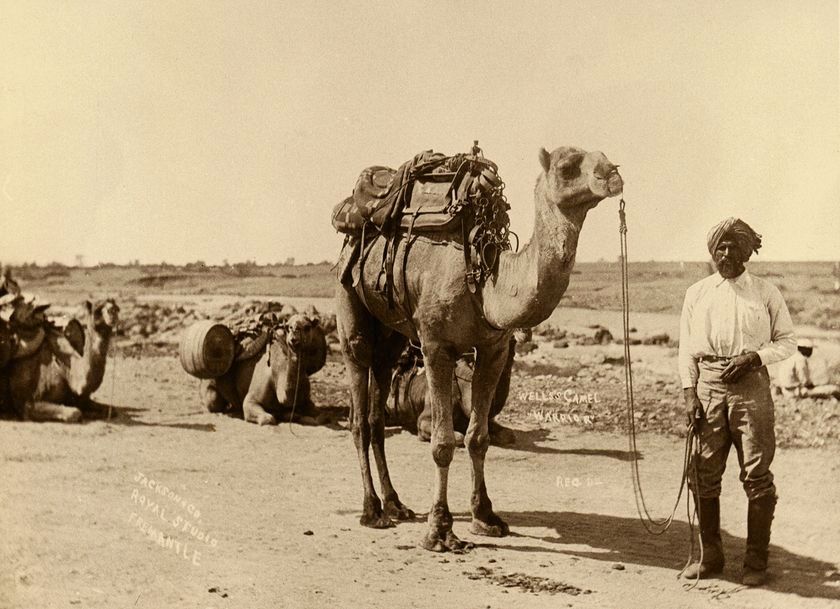
 Afghan cameleer, late 19th century Australia.
So why Ghan I hear you ask? It honours Muslim Afghan cameleers who arrived in Australia between 1860 and 1910 to help reach the country’s isolated interior. The first mosque in Australia was built in Marree at the start of the Oodnadatta Track to meet the needs of the cameleers. Construction of the railway began in 1878 in Port Augusta, reaching Hawker in 1880, Beltana in 1881, Marree in 1884 and Oodnadatta in 1891. Then, the final leg of the journey to Alice Springs was made by camel – hence the Ghan name – up until 1929 when the railway extension to Alice was completed. The Marree to Alice Springs line closed in 1980, replaced by another railway from Tarcoola further west, only gaining a connection to Darwin in 2004.
 Sunset on the William Creek Hotel
 Natasha in William Creek

 Inside the William Creek Hotel. My BSCB business card now has a forever home…
 It will cost you AUS$2 per litre to refuel in William Creek. The joys of the Outback!
 Natasha with the only other car in William Creek that day, the hotel manager’s.
After 136 km on the Oodnadatta Track we arrive at William Creek, population 10 and home to one of the world’s most remote pubs. William Creek is located on the world’s largest cattle station, Anna Creek Station, covering 23.677 sq km (9.142 sq mi), slightly larger than Israel and over seven times the size of the United States’ biggest ranch, King Ranch in Texas (3.340 sq km, 1.289 sq mi). We are welcomed by Rose who manages the hotel and pub, adorned with thousands of artefacts left by fellow travellers like many Outback pubs in Australia. After we sorted the details of our room, the conversation went roughly like this: “So could we have dinner here?” Rose: “Oh so you want to eat here?” “Uh, yes there aren’t any other options, right?” “Of course there are!” “?” “You also have Coober Pedy just 166 km away, Oodnadatta at 201 km or Marree at 210 km!” “Ummm we’ll settle for here then!” Cheeky Rose.


 Road conditions: Green all the way to Oodnadatta.
An evening of amazingly starry skies spent with friends is exactly what I was longing for in this trip. William Creek was good to us. The next day we embark on the next step of the journey, taking us a little more than 200 km to Oodnadatta. Given it hasn’t rained here for the past few months, all sections of the Oodnadatta Track are dry and “green” on the Road Conditions board, meaning all vehicles are allowed to drive on it. The landscape gets more and more arid as we penetrate further into the desert, a region encompassing Lake Eyre whose native title is held by the Arabana Aborigine people. The Toyota C-HR’s GPS calculates arrival times on unsealed tracks based on speeds of between 40 and 60 km/h. To be honest I am impressed it obliges on calculating anything outside of bitumen roads, as this wasn’t the case on both Havals I drove to neighbouring areas. But these tracks are so dry and graded so smoothly that peak speeds tilting over 100 km/h are not unreasonable. We arrive in Oodnadatta in a little less than three hours.

 Arrival in Oodnadatta.
The name Oodnadatta is derived from Arrernte Aboriginal language utnadata, meaning “mulga blossom”. Population is 277 including 103 indigenous Australians. Oodnadatta’s busiest era was during World War II as a vital stop on the Ghan Railway for the transport of military supplies to Darwin which was bombed by Japanese troops. Both the Australian Army and the Royal Australian Air Force set up local facilities to service troop trains and fighter aircraft headed to Darwin. After the closure of the railway line in 1980, Oodnadatta became a residential freehold town for Indigenous Australians. The Aboriginal school is the biggest employer here. Oodnadatta has recorded the highest reliably measured maximum temperature in Australia: 50.7°C (123.3 F) on 2 January 1960, hence the proud sign “Australia’s Hottest, Driest town” at the entrance pictured above.


 Natasha paying a visit of the Oodnadatta Pink Roadhouse.
But Oodnadatta’s main attraction is its legendary Pink Roadhouse. Lynnie and Adam, owners of the only shop in town, baptised the track we have just taken the Oodnadatta Track in 1979 to help what was merely a railway access to become a well known adventure drive from the Flinders Ranges to Uluru (Ayers Rock). Their shop became Oodnadatta Traders in 1983, then adding fuel to the service, and they decided to paint the store pink to easily identify their enterprise to travellers. The Pink Roadhouse was born. Well. All that build-up for nothing, as the staff of one was rather circumspect and the cabin we were offered was stifling hot with broken air-con! When the outside temperature under the sun is well above 50°C (it was the middle of Summer when we visited), that’s not a good combination. Gotta keep your standards up Oodnadatta!
Stay tuned for Part 2 of this Photo Report hitting the opal mining town of Coober Pedy…

Great test as usual! Although not being a Lada, I’d had called her Nathalie 😉
Oooooh controversial! I’m going to say that Lada doesn’t have the monopoly on Natashas…? 😉
Glad you enjoyed. Part 2 on the way.
All the best,
Matt
I agree Matt, the same way the day you test a Seat she won’t be necessarily Conchita! hahaha. Enjoying Part 2 right now